Categories
Case Studies Residential / Housing Streets and Spaces

Hammarby Sjöstad, Stockholm, Sweden

Introduction
Hammarby Sjöstad is a showcase urban extension containing a good mix of uses and sustainable residential development. A former derelict industrial site to the south of the city centre, the area is now identified as part of the city centre core. Masterplanned in the 1990s as part of the bid for the 2004 Olympic Games, the site was originally intended as a modern city district, with a core area housing the Olympic Village. Despite the failure of the bid, the original masterplan was largely adopted to govern the development and from the outset the municipality imposed strong environmental targets for buildings, infrastructure and transportation, alongside an ambitious goal of ‘twice as good’ (i.e a 50% reduction in overall emissions compared with new housing built in the early 1990s] – ref: http://www.hammarbysjostad.se/

Description
Location: Stockholm is located on Sweden’s east coast, to the west of the Baltic Sea. The central parts of the city consist of fourteen islands close to Stockholm’s archipelago. The new development district Hammarby Sjöstad (‘Hammarby Lake City’ in translation) spreads across the southern edge of one island, Södermalm, that is in Stockholm city core and the northern edges of two islands in the Greater Stockholm area of Nacka. The southern border of the central area of Stockholm was extended to incorporate the new Hammarby Sjöstad district.

Design and Development Process
The majority of this brownfield site was acquired by the City prior to undertaking a strategic master planning exercise. The City Planning Bureau divided the development phases into twelve sub-districts, and used an approach known as ‘parallel sketches’ to achieve a final masterplan for each of the twelve sub-districts: The City attracted three to four young innovative design teams to ‘test’ the strategic Masterplan and to draw up more detailed proposals for the sub-district. The city then evaluated the sketches and assimilated the best features from each to arrive at an agreed detailed Masterplan.

Subsequently a design code was prepared by the city and the design team in order to deliver the detailed plan for each sub-district. The design code implementation was secured in an appendix to the development agreement between the City and the selected development partner.

The code sets out principles under a number of headings:
 district character;
 layout, form and structure;
 architectural style;
 building types;
 building design principles;
 elements and colour;
 apartment standards;
 standards for additional services;
 design of courtyards and open spaces;
 detailed architectural and design principles for each plot; and
 the design of public spaces, parks and streets, including landscape, paving, lighting and street furniture.

The sustainable environmental measures are not part of the design code. In order to introduce diversity, each plot is designed and developed by a different team.

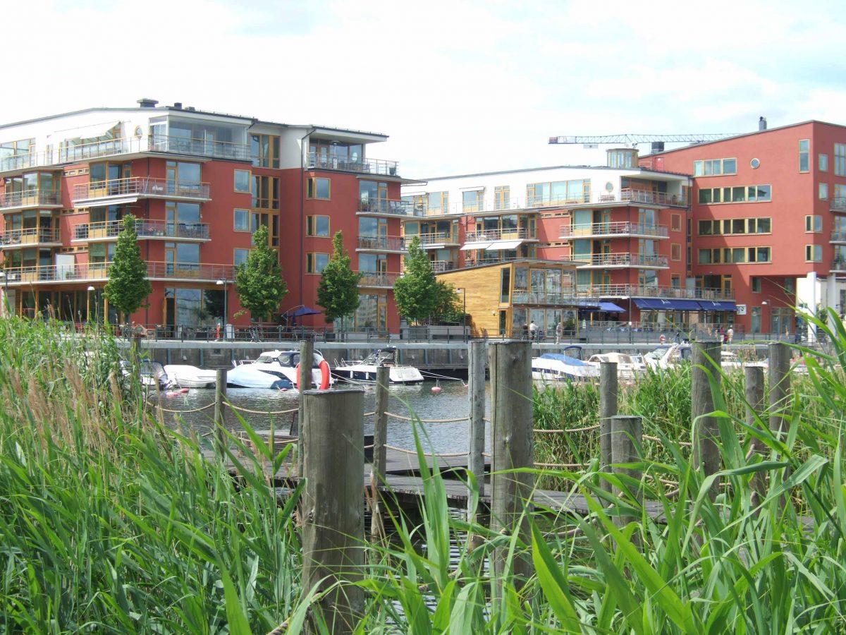
The built form is dominated by a 37.5m wide boulevard and transport corridor, connecting the key transport nodes and focal points. A grid structure has been used to organise the urban blocks with semi-open block form. The scale of development varies from four to five storeys along the waterfront and 6 to 8 storeys along the main corridor. Retail, food and drink uses are allocated at ground floor level fronting the major public space. Balconies are widely adopted to provide natural surveillance to the street, communal and private amenity. The buildings have a contemporary architectural style but sit within the traditional city block (and density) structure. Glass is used as the core building material, and is supported by the sustainability technology. Landscaped pedestrian and cycle routes benefit from the grid structure invested in by the city and form a permeable and legible environment. Developers are responsible for completing the external, semi-private landscape spaces within their urban blocks. The existing vegetation such as reeds and rushes are retained as a part of the new landscape and an existing protected oak forest has been preserved to create accessible woodland right next to the dense living environment. The development relates well to the waterfront and maximises views to water and green spaces.

Hammarby Sjöstad’s public transport system now forms a part of Stockholm’s integrated public transport network. Trams run along Hammarby Sjöstad’s main boulevard connecting with the city’s underground network and three new bus routes, including a night bus, all serve the area. In addition, a free pedestrian ferry links the southern part of Hammarby Sjö with the northern part on Södermalm (the next main island towards the city). A car-pool managed by car rental companies has been introduced, and is used by 7-8% of the total households.

Living spaces are generous by UK standards and a typical two-bed roomed flat has a floor area of 80m2, compared with the British new build average of 60m2. Floor-to-ceiling heights are 2.8m, rather than 2.4m, to allow more light. The homes vary in size from studios to five-bed family apartments.
Sustainability Credentials
Sustainability was integrated from the outset. This ensured that the necessary infrastructure was installed.

The key environmental measures include:

• Land decontamination and clearance, using biological rather than chemical treatment.
• Environmental assessment of all construction materials, which should be sustainable, non-hazardous and eco-certified where possible. The focus is on durable, recycled/recyclable materials such as glass, wood, steel and stone. The following materials are not permitted: chemically-treated timber; copper pipes for drinking water; virgin gravel and sand. Regular ‘eco-inspections’ are carried out to ensure compliance.
• The Combined Heat and Power (CHP) district heating system, fuelled by biomass and pre-sorted combustible waste provides most of the heat demand as well as generating electricity.
• The remaining heat demand is met by extracting waste heat from the wastewater treatment plant. The cooled and treated waste water is used in the district cooling network.
• A vacuum-driven waste disposal system conveys pre-sorted solid waste to be recycled, or used to produce heating and electricity.
• Domestic water consumption is reduced to 100 litres per person per day.
• Storm water is treated locally in settling tanks. It is then drained into canals which run through the site and is eventually released into the Hammarby Sjö, the adjacent sea.
• Solar panels and solar cells are installed on the roofs of some buildings.
• ‘Ecoducts’ ie planted viaducts and green corridors link the development with the vast forested area of the Nacka nature reserve to the south of the site.
• Substantial investment has been made in public transport provision, in the form of a new tram link, good bus routes, and free pedestrian ferry. A car pool with around 30 biofuelled cars is used by 10% of households. There are numerous pedestrian and cycle paths. The aim is for 80% of all journeys to be by public transport, foot or cycle by 2010.
• A methane digester is used to produce biogas for vehicle fuel and around 1,000 gas stoves in Hammarby. The remaining sludge is used as a fertiliser in the forestry industry.
• Super insulation [250mm+], low energy lighting and triple glazed windows are the norm.
• GlasshusEtt, information centre acts as a community education centre to promote sustainable lifestyles. The building itself has been constructed to achieve a good indoor climate with low energy consumption. This has been done through the installation of solar panels; using a biogas boiler to meet peak heating requirements; a biogas stove for the kitchen area; and a heat pump that takes the energy from the pumping stations own moist heat and the waste heat produced by the mains power installation, provide heating. For the first time in a Swedish commercial building the GlasshusEtt used a fuel cell (an advanced energy converter) generating oxygen and energy. Biogas is used for the fuel cell.

Evaluation
Stockholm Municipality have successfully used their power as a land owner to create in Hammarby Sjostad a remarkably successful and sustainable urban neighbourhood, combining a high quality public realm and residential area with a diverse range of shops, services and facilities. High levels of political leadership and municipal partnerships as well as an integrated planning approach and a collaborative design process, have ensured that the core principles of the masterplan were delivered. Key successes lie in the following areas:
• The use of the ‘parallel sketches’ approach resulted in a high quality masterplan for each of the sub-districts.
• A high quality of masterplan ensured a high quality of public realm, permeable urban form, accessibility for all and a successful green space network with a good mix of land use.
• The use of a design code raises the developments overall quality, whilst allowing for a variety of creative responses.
• Essential public sector partnerships and investment in infrastructure and public transport stimulated the market for residential development and helped secure sustainability criteria.
• Commitment to high standards of environmental performance based on ‘closed-loop’ technologies and district-wide solutions (50% reduction in emissions compared with the 1990s Swedish standard). By the time the development is completed it is estimated that residents will produce 50% of all the energy they need, via district wide systems which recover energy from liquid and solid wastes.
• A well-resourced, highly skilled team within the City of Stockholm, capable of making careful judgments about design quality.

Some opportunities were not pursued in terms of the environmental treatment and there is no provision for recycling the collected rainwater (e.g. for WC flushing); there is no overall carbon reduction target in the project; the renewable energy ambition has not been pursued to its full potential. Overall, Hammarby Sjöstad is a very high quality scheme exemplifying the benefits of well designed layout, good use of coding and a commitment to sustainable transport and utility infrastructure.

Acknowledgements
In June 2008 a delegation from the Commission was hosted by Professor Professor Gören Cars, Head of Urban Planning and Environment and Jerker Söderlind, Researcher at the Kungliga Tekniska Högskolan (Royal Technical Institute), and they provided an overview of the Swedish planning system. The Head of the Strategic Division (Planning Department), Torsten Malmberg, presented the strategy for the development of the city which provided context for the urban extension project at Hammarby Sjöstad. Malin Olsson, head of Division (Planning Department), and Kristina Meynes, Development Department of Stockholm City Council hosted the site visit.

Further information
Hammarby Sjöstad 2006 (Brochure) at http://www.stockholm.se/files/99800-99899/file_99882.pdf
Stadsbyggnadskontoret (2005) Kvalitetsprogram för gestaltning del av Lugnetområdet. Hammarby Sjöstad.
www.hammarbysjostad.se
www.stockholm.se/hammarbysjostad
Sweden’s green utopia: http://www.building.co.uk/story.asp?sectioncode=583&storycode=3096706&c=0

Categories
Case Studies Streets and Spaces

Castle Square – Caernarfon

Planning and Design Process

Concept

The town’s main square is part of a World Heritage Site and was previously dominated by clutter, traffic and guard rails restricting pedestrian movement. The design concept originated in the desire to open up clear views to the Caernarfon castle and other historic buildings around the square. The public realm was to be a simple foreground plane to the high quality built form. The architecturally valuable cluster of the Presbyterian Church, adjacent banks and war memorial were developed as a counterpoint to balance the castle’s dominance of the space and by the addition of a new fountain and stepped seating area, where previously there had been an unattractive wall.

Objective

A primary objective was to make the square more inviting and usable for pedestrians. The design therefore required particular consideration of traffic management relating to the whole town centre, along with specific issues relating to the square such as the operation of markets, special events, taxi ranks, tourism and visitor management. The scheme was deliberately simple in approach aiming to create an uncluttered setting for the attractive buildings surrounding the square and the castle.

Shared Surface

The concept for a clean, flexible space led to proposals for a shared surface where pedestrians and vehicles have equal rights to the space. This approach encourages low traffic speeds and cars entering the space move more slowly than on conventional streets, enabling traffic calming, which encourages a greater sense of safety for pedestrians who wander across the square or meet to chat in the middle of the square leaving vehicles to negotiate their way around them. The lower traffic speeds tend to personalise interactions between motorists and between vehicle users and pedestrians so that potential conflict is reduced or resolved amicably in the same way that pedestrians negotiate one another on foot in a busy street.

Materials

Existing civic sculptures were relocated in the new square and a simple palette of new lighting, signage and furniture were also included, further enhancing the quality of the public realm.

Sustainability Outcomes

Materials

The surfacing materials include locally sourced Welsh Slate and Granite all from within 30 miles of Caernarfon.

Categories
Case Studies Streets and Spaces

Drift Park – Denbighshire

Planning and Design Process

Regeneration

The design process began in May 2002, with the commissioning of a study to establish a conceptual design for the project, seen as a key component of the regeneration of west Rhyl. In this respect the strategy follows the principles established in nearby north west cities, using environmental improvements as “quick wins” in the first phase to act as a catalyst and boost investor confidence in the regeneration process.

Concept

Following a competitive tender process organised by the Environment Directorate of Denbighshire County Council,  BCA Landscape (Chartered Landscape Architects, Liverpool) were appointed to carry out the Study, producing the “Drift Park” concept as the way forward.

Consultation

Consultation was an integral part of the study, to ensure that the proposals respect the development context and meet the approval of the Rhyl community. This began with a three-day exhibition (July 2002) at the White Rose Centre, introducing the community to the preliminary ideas and objectives.  The proposals were then developed to provide the necessary detail for the Planning Application and consultation with the community and elected members continued. Feedback from these sessions informed design development, and was particularly important in establishing a preference to complete the work as a single action, rather than in sections over two years. As part of the detail design for tender/construction further consultations were carried out with; Business interests – particularly Kiosk tenants; Denbighshire County Council departments; Welsh Development Agency; and the Design Commission for Wales.

Artwork

Consultation continued in the detail design stage as the Local History Group helped to select the images and memories to be portrayed in the artwork, and children from Ysgol Mair Primary School were involved in the design and production of the ‘Fish Faces’ feature in the Water Play Garden. Inclusion of bespoke artwork as an integral part of the design from the outset  in order to tell a story of Rhyl’s development as a resort and further enhance “ownership”.

Materials

The challenging coastal environment required careful consideration of the use of materials that could withstand these conditions. ‘Hard’ materials were chosen to weather naturally in the environment – pre-cast concrete, natural stone and resin-bonded gravel for the footpaths, purpleheart timber, through-colour render, and a limited amount of galvanised metal; no painting has been specified for external areas. Wind-blown sand is a particular problem, and the general arrangement introduces low pre cast concrete walls to restrict the deposition of sand to the seafront promenade (the walls also double as seating). As some wind-blown sand will still be blown into Park the width of the pathways is designed to accommodate vehicles for its removal.The planting is then selected to be robust – the main structure is provided by Maritime Pine trees, which will be contorted by the prevailing wind to provide a dynamic reflection of the location; their establishment is assisted by sacrificial ‘pioneer’ species of willow and alder. Colour is provided by seasonal perennials, planted in bold drifts along West Parade, chosen for the added advantage of producing new foliage each year and thus free of the damaging effect of salt-laded winter winds.

Sustainability Outcomes

Reuse

The entire site was stripped to remove all residual paving materials and the remains of previous attractions: where appropriate the arisings were used on site to fill voids (such as the former boating pool) and to create the sub base for the new landform (a key component of the Park design). Re-usable materials (such as stone copings and artefacts) were removed to the local Denbighshire County Council Depot for storage and re-use.

Materials

Where the importation of material was unavoidable these were obtained from sources as close to Rhyl as possible – for example, the topsoil came from Bodelwyddan (within 3 miles), stone from Colwyn Bay, and slate from Penrhyn. The selection of durable hard and soft materials will also help to reduce maintenance inputs.

Community

The community consultation strategy has also developed a real sense of “ownership” in the town, contributing to a sense of respect and helping to minimise vandalism (and the need for repair) to a very acceptable minimum.

Categories
Case Studies Streets and Spaces

Newport City Footbridge

Planning and Design Process

Historic context

The bridge’s dramatic crane structure provides a symbolic link to the site’s earlier use as a trading wharf. It is also a prominent feature of the city skyline, drawing attention to the river that is hidden from much of the city centre.

Urban form

Placing the main supports on the west bank also reflects the pronounced change in the urban scale and grain from the commercial heart of the city on the man-made west bank, to the domestic uses and soft landscape on the east side. The deliberate concentration of major structures on the west bank has many practical advantages. The vast majority of temporary and permanent works were kept away from the nearby dwellings on the east bank. Construction work was simplified, with no requirement for any works on the tidal riverbed and avoiding impact on the local river ecology. The existing car park on the west bank also provided an ideal construction site for final assembly of the structural components before installation.

Structure

The primary supporting structure is of four masts, standing in pairs, which support the 145-metre long bridge deck from the west bank. The bridge deck loads are transferred to ground level by two 120mm diameter cables which also act as stays for the masts. The deck is five metres wide and 4.1 metres above water at mean high tide level.

Construction

Atkins and Alfred McAlpine created a lifting and construction sequence which ensured the spectacular masts could be jacked safely into place.  The masts were installed in pre-connected pairs, followed by the bridge deck in five elements corresponding to the cable stay support pattern. Final connections to each riverbank were achieved with two pre-cast concrete abutment units.

Materials

In addition to the structural steel, the bridge includes nearly three kilometres of stainless steel wire.  With a load bearing capacity to carry 2,000 people, the structure includes 20 tonnes of dampers to prevent vertical and lateral oscillation. The masts are constructed from rolled and welded sheet steel and ‘fixed’ in mountings with 450mm long stainless steel pins weighing 500kg each. The bridge has a design life of 120 years.

Sustainability Outcomes

Ecology

The River Usk is a Site of Special Scientific Interest and a Special Area of Conservation. Listed for its flora and fauna, the Usk contains protected fish species, and otters and is edged with sensitive salt marsh maritime flora. Therefore the bridge had to avoid damage to the local river ecology.

Habitat protection

A key early design decision was to avoid the installation of any temporary works in the river. This not only combated safety risks but also avoided damage to the wildlife habitat. It was also important to minimise expenditure on temporary works to maximise the budget available for permanent works. This strategic decision immediately ruled out an arch and led to an exploration of masted and cable-stayed structures.

Categories
Case Studies Streets and Spaces

Denbigh Townscape Heritage Initiative – Denbighshire

Planning and Design Process

Management

The initiative was managed through three teams:

  • The Denbigh Partnership, which comprised the Denbigh Civic Society, Denbigh Town Business Group, Popeth Cymraeg and the Denbighshire Enterprise Agency;
  • The Project Board, which consisted of the funding bodies, including representatives from the Welsh Assembly Government, Cadw, Wales Tourist Board (Visit Wales as of 2006), Denbigh Town Council and Denbighshire County Council; and
  • The Project Team, which was the internal support group of Denbighshire County Council.

Objectives

The project ran from December 2000 through until December 2006. Its objectives were:

  • To increase awareness among local property owners and residents of the qualities of the heritage in the town centre and the opportunities presented by the initiative.
  • To encourage the take up of grants.
  • To involve the local community in the initiative decision making process – through participation procedures and representation on the Partnership.
  • Ensure high quality repair, reinstatement and new work in order to improve the image and character of the area and to reinforce local distinctiveness.
  • Adopt policies and procedures that facilitate the process of economic regeneration and heritage enhancement.
  • Ensure that all partners in the Initiative and County Council services are working together to benefit the area – encouraging other regeneration and enhancement schemes complementary to the aims of the Townscape Heritage Initiative.

Renovation 

Work was carried out on some 20 properties and a public space, improving the fabric of the town centre. These renovations sought to return neglected buildings in the conservation area to their former glory, both in terms of façade conservation, and in re-establishing many of the current building uses. In particular, new and employment uses were encouraged, as well as upgraded housing and educational and community facilities.

Sustainability Outcomes

Reuse

Re-use of historic buildings is compatible with the principles of sustainability. Such buildings are often suitable for a number of uses due to their structure, space and location. By repairing rather than replacing them, the consumption of additional precious resources is kept to a minimum.

Construction

Repairs were carried out using traditional building methods and materials, which are generally less wasteful in term of natural resources, consume less energy in their production, and because they involve craftsmanship and traditional skills, are often carried out with minimal use of power tools.

Materials

The use of traditional materials and processes, such as lime pointing and rendering, makes for ‘breathability’, and assists in preventing problems associated with modern living, such as condensation, thus limiting the development of mould growths that can lead to respiratory disease, and ensuring longevity of the building. Traditional materials are also more environmentally sound, being sourced from natural and sustainable products, and having low or zero emissivity are often safer for allergy sufferers. They are also more easily and safely removed and disposed of or re-used.

Economic

Re-use of vacant space, especially in the town centre, provides accommodation suitable for commercial enterprise, or residential units, sustaining both the local economy and also the heart of towns such as Denbigh. This maintains the low levels of outward migration that have, historically, helped to keep families together through the generations and preserved the language and culture of the area. Homes can be provided close to facilities, thus saving on travel to work, and encouraging walking, cycling and public transport which provide easily accessible alternatives to the car.

Historic buildings

Whilst many historic buildings do not meet current thermal and acoustic standards, in many cases it is possible to upgrade them without damaging the character, and such work can often be undertaken during the regular course of repair and maintenance programmes. The close-knit fabric of a historic town such as Denbigh has an advantage in that most buildings are attached to their neighbours, with a consequent reduction in energy loss through external walls. Where appropriate, measures such as double glazing and thermal insulation, particularly of roofs, has been carried out.

Quotes

In 2004, the Royal Town Planning Institute awarded it the Wales Award for Planning Achievement saying that it was ‘..a good demonstration of how sensitive regeneration of the historic environment can contribute to community and business confidence’. Furthermore, the RTPI was impressed with the important role planners played in this ‘well-coordinated, multi-functional approach to regeneration’.